Month-Long Study Focused on Improved Air Quality Forecasting
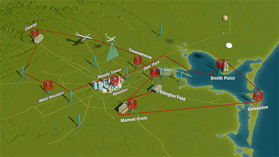
NASA Image (Above): Map of Houston 2013 DISCOVER-AQ Campaign. Two NASA aircraft flew over the Houston area throughout September, one as low as 1,000 feet, to measure air pollution with a number of onboard science instruments. (Image Courtesy of NASA)In September, Houston air quality measurements were taken by mobile labs, ground instruments, airplanes and a satellite as part of a project designed to help scientists understand how to better interpret and forecast air quality using satellite data and numerical models.
The effort was part of a multi-year NASA air quality study, DISCOVER-AQ, which also includes measurements in Washington, D.C., Baltimore, Los Angeles, and Denver. University of Houston atmospheric scientists, Barry Lefer, Robert Talbot, Yunsoo Choi, and adjunct professor Gary Morris participated in the project along with 15 UH undergraduates and graduate students.
Presently, it is difficult to accurately measure surface air quality based on satellite data.
“Satellites measure the total amount of pollution in the atmosphere, so the readings get the upper level pollutants that don’t affect us as much, as well as the lower level pollutants,” said Barry Lefer, associate professor in the Department of Earth and Atmospheric Sciences. “The trick is how do you subtract off the stratosphere to get to the measurements that you want?”
Massive Air Quality Data Collection
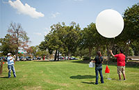
Adjunct professor Gary Morris and UH undergraduates Erika Marrero and Daniel Sierra prepare to launch a weather balloon outfitted with ozone measuring equipment. Launches from UH occurred every day in September.During the project, scientists collected an enormous amount of data similar to what a satellite measuring air pollution would collect.
Two NASA aircraft equipped with scientific instruments flew a fixed route over Houston gathering air quality data. Simultaneously, five mobile labs equipped with similar devices drove approximately the same route. Measurements were also being made at stationary locations around Houston and with weather balloons.
“Mobile and stationary measurements, a plane with downward views simulating satellites, a plane getting vertical profiles by spiraling between altitudes – all those measurements will be compared with what the satellite got for the same day,” Lefer said.
The satellite measurements were made by a fleet of Earth-observing satellites, called the Afternoon Constellation or “A-train,” which passes over Houston each day at 1:30 p.m.
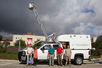 “UH had two mobile labs, instrumentation at 6 of the 15 ground sites, and daily weather balloon launches gathering ozone measurements,” said Lefer. “We also hosted several monitoring devices from other universities on our rooftop lab at Moody Towers and in our mobile labs.” “UH had two mobile labs, instrumentation at 6 of the 15 ground sites, and daily weather balloon launches gathering ozone measurements,” said Lefer. “We also hosted several monitoring devices from other universities on our rooftop lab at Moody Towers and in our mobile labs.”
The sampling area covered the Houston metropolitan area ranging from Conroe in the north to Galveston in the south. “The flight path was sort of a figure eight shape,” Lefer said. “The planes flew the route three times each flight day. With nine flight days, we were able to get good statistics; some flights were on clean air days and some on dirty days.”
One of the NASA planes flew at 26,000 feet taking downward gaseous and particulate measurements mimicking a satellite. The other plane flew a similar route at lower altitudes and also made spirals around eight locations sampling the air at various levels over those sites. UH’s Moody Towers was one of the spiral locations.
Moody Towers Measurements
“On flight days, there were three flights over campus at approximately 10 a.m., 12:30 p.m. and 3 p.m.,” Lefer said. “The plane flew around Moody Towers starting at 1,000 feet and making about 3-4 spirals until it reached 12,000 feet. The spiral was big, about 2-1/2 miles in diameter.”
Moody Towers also had instrumentation on its roof that measured everything the plane measured and more. Some of the instrumentation is there year-round and other devices belonged to visiting scientists from Baylor University, Texas A&M University, University of Colorado, Pennsylvania State University, Appalachian State University, the Environmental Protection Agency, NASA, USDA, and NOAA. UH’s mobile labs also carried equipment from Chalmers University (Sweden) and Rice University.
On Moody Tower, Talbot’s instrumentation measures carbon dioxide, methane and mercury, and Lefer is measuring ozone, formaldehyde and four other pollutants. These measurements are made year-round.
Choi’s air quality forecasting model helped the NASA project team reach its decision each afternoon on whether to fly the planes the next day. Morris launched weather balloons outfitted with ozone measuring equipment each day from campus.
“The results of this study are going to help us get a better understanding of what the satellite is showing us,” Lefer said. “If we are better able to interpret satellite data, then we can make more accurate air-quality analyses and forecasts. And, that will have a big impact on human health.”
University of Houston’s participation was funded by grants from the Texas Air Quality Research Program and the Texas Commission on Environmental Quality.
- Kathy Major, College of Natural Sciences and Mathematics |