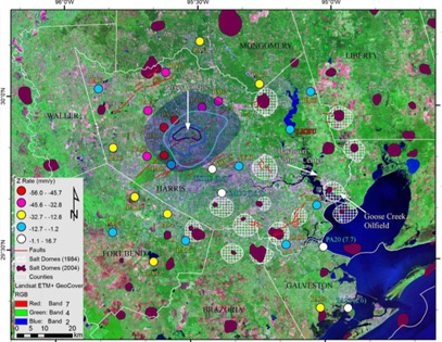
Rates of vertical motion observed in this study
A large section of northwestern Harris County – particularly the Jersey Village area – is sinking rapidly, according to a University of Houston geologist who has analyzed GPS data measuring ground elevation in the Houston area.
Some points in Jersey Village are subsiding by up to 5.5 cm a year, said Shuhab Khan, an associate professor of geology. Khan, along with geology professor Kevin Burke and former Ph.D. student Richard Engelkemeir, studied a decade’s worth of detailed GPS data measuring the elevation of various points throughout the Houston area. They recently published their findings in the journal Tectonophysics.
A sprawling area – roughly 30km by 30 km – of northwestern Harris County is gradually subsiding but the points in Jersey Village are sinking fastest, Khan said.
The raw data was obtained from the Houston-Galveston Coastal Subsidence District. Khan’s study processed and analyzed GPS data from more than two dozen measurement points throughout the county, covering 1995 to 2005. Extrapolating data from six measurement stations, Khan roughly marks the boundaries of the vast subsiding area. At three of those measurement spots, centered around Jersey Village, the sinking was particularly fast.
Because GPS can pinpoint location with millimeter precision, it is an excellent tool to measure even the most subtle changes over time in ground. The most likely reason for the sinking of Jersey Village is the withdrawal of water from deep beneath the surface, Khan said.
While groundwater withdrawal has ceased in most of the Houston area it continues in the northwestern part of the county which has seen a rapid growth in population. The fate of the Brownwood neighborhood near Baytown illustrates the potential consequences of rapid subsidence, Khan said.
When the residential subdivision was first developed in the 1930’s, ground elevation was about 3 meters above sea level. Forty years later neighborhood stood just half a meter above sea level and was subject to frequent flooding. In 1983 Hurricane Alicia destroyed the subdivision and the area became the Baytown Nature Center. The sinking of Brownwood was attributed to the massive groundwater withdrawal by the petrochemical plants along the Ship Channel.
However, Khan hopes, the new data – which pinpoints precisely where and how quickly the ground is moving – can aid the region’s builders and city planners in mitigating the damage caused by the ongoing subsidence northwest of Houston.
Khan’s analysis also showed some gradual surface uplift southeast of Houston along the coast. The coastal area has several vast salt domes deep beneath the surface. Because salt has a lower density than common crustal rocks, it rises and pushes up the ground, Khan said.
More study might also link salt dome activity along the coast to the surface movements occurring elsewhere in the region, he added.
Khan’s previous work on the region’s elevation has already garnered widespread attention from local media, homeowners and builders. Geologists had long known for the existence of faults in southeast Texas but in 2008 Khan produced a comprehensive map pinpointing the precise locations of some 300 faults traversing the Houston area.
These local fault lines are not the kind that wreak havoc in earthquake-prone California, but they can move up to one inch a year. Such movement over several years can cause serious damage to buildings and streets that straddle a fault line. |

